Marine pest by location - map instructions
The Marine Pests by location page is designed to be a simple way to obtain a list of known marine non-indigenous species (NIS) that have been detected in locations around New Zealand. The sources of data are the same as those described for the “Search for species” detailed mapping page.
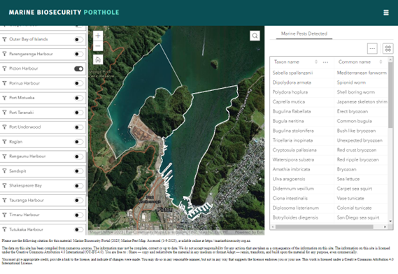
Toggling or switching, on and off a location on the left-hand side of the map, will zoom in and show the defined boundaries of the location selected on the New Zealand map in the centre of the screen. The map will show no specific data, only the boundaries of the selected location. A list of species for that location will automatically be filtered in the “Marine Pests Detected” table. This list includes the full scientific species name or “Taxon name” and where possible, a known “Common name”, or where common names are not known, a general descriptor of the type of animal (i.e., Amphipod).
A presence record is recorded regardless of the substrate or situation the species was recorded from. A species recorded as being “detected” could be one detected from permanent substrate or from a vessel, it is purely a presence record from a location.
For example, if we select Picton Harbour – The map will zoom into the area we have considered to include as Picton Harbour (based on the surveys conducted as part of the NMHRSS). The location toggle or switch is on the left-hand side and a list of marine NIS that have been detected in this location is displayed on the right.

The first species that appears on the list is the Mediterranean fanworm Sabella spallanzanii. As of September 2023, the Mediterranean fanworm has only been detected from vessels, it is actively managed by agencies in the region, and is currently not known to have established a self-sustaining population on permanent substrata. However, it is recorded as a detected marine pest in the region. This scenario only occurs for a small number of marine NIS in New Zealand and if you want to confirm that a particular species is established at a location look at “Search for species” detailed mapping page to see if it has been detected over a number of years.
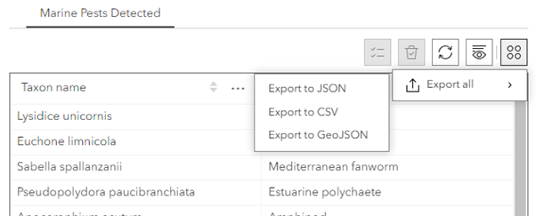
At the top right of the “Marine Pests Detected” table an option exists to export selected records. By clicking on the “Actions” button an export option appears. This option will work with one or more selected locations from the location list on the left of the screen. There are three format options for export: JSON, CSV and GeoJSON. By clicking one of these options a download will be created in your selected format and can be found in the location your internet browser downloads to.

The data download includes the location, taxon name and a common name for each record. The “ObjectId” and “Count” columns are required for spatial data formatting and do not represent any important information.

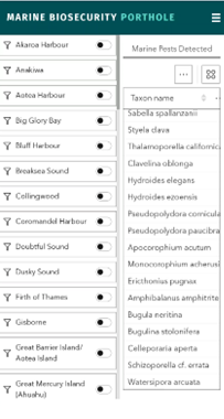
On the mobile version of this webpage there is no map. Location toggles or switches are present on the left and the table of marine pests is displayed on the right. The list can be scrolled up and down and the table can also be scrolled left and right to see the common names. The download option is also available in the mobile version of the webpage.

As described in the Sources of data, information on marine NIS in New Zealand come from a variety of sources verified by national and international taxonomic experts. Some species may appear in this list that are well known and have been present in New Zealand for a long time. It may be surprising to know some are not native to New Zealand. For information on the criteria used to determine the biosecurity status of marine organisms in New Zealand please refer to Table 1. in Seaward et al. (2015).
Finally, if more detailed data is required on marine NIS detections, e.g., location, date and method of detection, refer to the “Search for species” detailed mapping page and instructions.